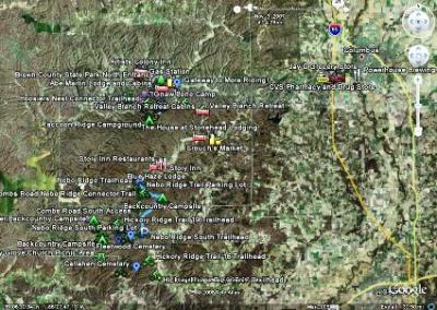
If you've never been to Brown County before or you just want to learn more about the area you should definitely check out our new Brown County Mountain Biking Google Earth Map. You must have Google Earth installed on your computer to view the file. Google Earth is a free program that is an absolute must to have. If you don't have it, you can download it here.
Our map is designed for mountain bikers, and it has all kinds of amenities on it including our favorite restaurants, lodging, gas stations, coffee shops, brewpubs, drug stores, groceries, laundromats, liquor stores, backcountry campsites, historical sites, great photo ops, and more. Click on any of the placemark icons and a description (and sometimes photos) will pop-up. It also has GPS trail overlays of the complete Brown County State Park trail system and the Nebo Ridge Trail. These are the two most popular riding destinations in the area. We'll soon be adding GPS trail data for Hickory Ridge, Gnaw Bone, and Valley Branch Trail systems as well. If anyone out there already has GPS data for any of these trails please send us the files to info@browncountymountainbiking.com.
The map will continue to evolve, grow and improve as time goes on. If you have a recommendation for a change or an addition please let us know.

No comments:
Post a Comment