Tuesday, December 30, 2008

Saturday, December 20, 2008
Will Brown County Take Advantage of Its Prominent Mountain Bike Destination Status?

Five years ago, I would have hardly believed that Brown County would become the mecca of Midwestern mountain biking. Brown County is now a contender for that title, and it may even have its sights set higher in the very near future. However, Brown County isn't alone in seeking that title. There are towns all over that are in various stages of developing mountain bike trails and tourism. Competition will be fierce, but I am confident that Brown County will continue to rise to the top in this category because of its convenient location to so many urban areas, its beautiful and interesting topography, its amazing quality and amount of purpose-built trails, and its existing tourism economy.
Last week I found this article about devoloping mountain bike tourism in Jackson County, Alabama. It's amazing how similar that situation is to where we were in Brown County just a few years ago. I've been giving the same sales pitch to people in Indiana and in Brown County for going on five years now. Today we find ourselves in the position of actually being a mountain biking tourism destination and a potential mecca for Midwest and eastern US riding. The problem is that it's hard to convince people in the Brown County area that it is true.
If the people in and around Brown County want to take full advantage of what they have been given then they need to take a crash course in catering to mountain biking tourism very soon. No doubt many Brown County business owners will continue to sell knick-knacks and fudge to fill their tills. Hopefully there will be some saavy business owners that will also harvest the potential of mountain bikers that come to town and want to spend lots of money. A good part of Brown County's viability in the future may rely on catering to outdoor recreation, especially mountain biking.
Will Brown County take notice in 2009? I believe that their very survival depends on it. The economy is in the dumps. Brown County's tourism numbers have been on the decline for several years. Local businesses are hurting. Will they use the amazing amenities and potential that has been placed at their feet? This coming season will be the litmus test.
If anyone reading this would like some help in this regard we have all kinds of talented people and resources at our disposal to help you make it happen. The Hoosier Mountain Bike Association and advocates like myself can't do it by ourselves. We need buy-in and participation from the local community. Without that, we may just be spinning our wheels.
Good reading:
Destination Mountain Biking: Positioning Your Community for Mountain Bike Tourism
Tuesday, December 16, 2008
Unlocking the Secrets of Brown County Mountain Biking
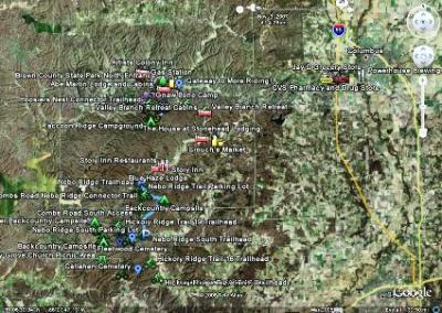
If you've never been to Brown County before or you just want to learn more about the area you should definitely check out our new Brown County Mountain Biking Google Earth Map. You must have Google Earth installed on your computer to view the file. Google Earth is a free program that is an absolute must to have. If you don't have it, you can download it here.
Our map is designed for mountain bikers, and it has all kinds of amenities on it including our favorite restaurants, lodging, gas stations, coffee shops, brewpubs, drug stores, groceries, laundromats, liquor stores, backcountry campsites, historical sites, great photo ops, and more. Click on any of the placemark icons and a description (and sometimes photos) will pop-up. It also has GPS trail overlays of the complete Brown County State Park trail system and the Nebo Ridge Trail. These are the two most popular riding destinations in the area. We'll soon be adding GPS trail data for Hickory Ridge, Gnaw Bone, and Valley Branch Trail systems as well. If anyone out there already has GPS data for any of these trails please send us the files to info@browncountymountainbiking.com.
The map will continue to evolve, grow and improve as time goes on. If you have a recommendation for a change or an addition please let us know.
Wednesday, December 10, 2008
How Does Brown County Compare to Other Great Trails?

Despite the amazing trails and success of Brown County, there are still some skeptics out there. We frequently talk to people that have doubts that there is enough elevation change in Indiana to create a world-class trail system. Those that have ridden at Brown County already know that it's not only possible, it's already on the ground waiting to be ridden!
What follows is the first in a series of numerical comparisons of Brown County to other well-known trails. For the comparisons, we'll rely purely on GPS data that is publicly posted on the web. It's important to note that these comparisons won't take into account many things such as flora, fauna, soil type, climate, views, trailhead amenities, points of interest, etc. In those regards, I think that the experience at BCSP is unique, yet comparable to riding experiences that I've had at other great trail systems all over the country. For those riders out there that want to see the "numbers" I think you'll be pleasantly surprised at what we've accomplished in the Southern Indiana hills.
The representative ride that we'll use from BCSP is this GPS track of a quintessential, long ride in Brown County. It's currently the route that I recommend to visitors that want a half-day/full-day epic ride. It's a 23 mile route. Over its course it has an elevation gain/loss average of 3,140 feet. It covers every inch of officially opened trail as of December 2008. It does not include any of the new Pine Loop (beginner) or Schooner Trace Trail (expert) that will open in Spring of 2009. It's interesting to note that this route can be made significantly more difficult by taking the long way around Aynes Loop and North Tower Loop on the return trip. That adds about 5 miles and over a thousand feet elevation change.
For the first trail comparison we're going to use the Berryman Trail in the Mark Twain National Forest in Missouri. This has long been a popular trail in the United States, especially the Midwest. It was officially designated as an IMBA Epic in 2001. Here's a link to the Berryman Trail GPS information that I'll be using for the comparison.
The first thing that jumps out when you compare Brown County with the Berryman is how freakishly close the numbers are. The Berryman loop is just under 24 miles. The Brown County ride is just over 23 miles. The elevation change on the Berryman loop is 3,143 feet. The elevation change on the Brown County ride it is 3,140 feet. The elevation on the Berryman loop ranges between 800-1200 feet above sea level. The elevation on the Brown County ride ranges between 650-1050 feet above sea level.
So, there you have it. There are trails of "epic" quality right here in Indiana. The numbers don't lie. When you add other things to the equation like the extremely high quality and diversity of the BCSP trails, the generally mild riding weather, the beautiful flora and fauna, the fantastic views, and the nearby amenities of the quaint tourist town of Nashville, Brown County really starts to "add up".
I want to be the first to say that numbers don't do it justice. Come see it for yourself. Plan a trip here for next season. Come for a day. Stay for a week. You won't be dissapointed. It's also important to remember that after you ride for 2-3 days at Brown County you may also want to check out the wonderful Nebo Ridge Trail or some of the other almost 150 miles of legal trail in and around Brown County.
Monday, December 8, 2008
Get Out! Online Magazine Features Brown County Mountain Biking
Mary Reed of Get Out! magazine recently did a really nice feature on mountain biking at Brown County State Park. Get Out! is an online magazine whose mission is "to inform, entertain and inspire all citizens of the Ohio River region to pursue an active, healthy lifestyle through outdoor adventure and to learn more about how to be stewards of our natural environment." We are hoping to see lots of Get Out! readers next season on the trails.
Tuesday, December 2, 2008
New Pine Loop Will Open Soon

Yet another new trail will open at Brown County soon. It will be called the Pine Loop. It is the yellow trail on this satellite photo. It will be a pure beginner trail, but that doesn't mean that it won't be a great warm-up or warm down for advanced riders that are parked at the North Gate or Upper Shelter. The trail traverses through a large pine tree stand, it also meanders through a few ravines. It crosses the creeks in the ravines using freshly built wooden bridges. There are four bridges total on the loop. There is also some nice rock work and some crib walls that were constructed to make the switchbacks. This will be a fantastic trail for teaching kids and beginners.
Another Blog Post About BCSP
Here's a blog post from a guy that lives in Sister Bay, Wisconsin. He rode at Brown County over the Thanksgiving holiday, and he has nice things to say about it. He does suggest that someone should take the time to remove the leaves from the trail! We'll be sure to stop the trail builders immediately. They should definitely be removing pesky things like leaves from the trails instead building buttery, flowing, new singletrack.
Monday, December 1, 2008
Web Posting About BC Ride
I was emailed this web posting about a gentleman's first mountain bike ride at Brown County. Although it sounds as if he was grossly unprepared, he still managed to have a terrific time, and he thoroughly enjoyed the trails. It just goes to show that beginners and advanced mountain bikers both can ride the trails and have a great time.
Saturday, November 29, 2008
New BCSP Video Found on YouTube
Here is a nice video I found on YouTube that some guys recently shot at Brown County. There is an absolutely spectacular wreck at 1:20! It's on the Hesitation Point log bridge crossing.
Thursday, November 20, 2008
Gateway Cyclist Riders Come From St. Louis
Last weekend we had large groups from Chicago and St. Louis in the BrownCo. Here are the St. Lou photos. As word spreads, it's not rare to see lots of out-of-state plates in the parking lot. Although the weather was questionable, and it had rained a few days previously, the riders from out of town were amazed to find great trail conditions. We locals know that the trails are very resilient to bad weather. It's a testament to how well thought-out and built the entire trail system is.
Wednesday, November 19, 2008
New Section Open on North Tower Loop

There is a large section of new trail on the North Tower Loop. It's the light green trail on this satellite photo. It replaces the old fire-road downhill that used to run from the North Tower Loop Connector intersection down "the short way" out towards Aynes Loop. This old portion of trail was wide and fast, but it doesn't hold a candle (climbing or descending) to this newly-built trail. Almost all of this trail was lovingly built by machine by Alex Harrington and Alex Stewart of Spectrum Trail Design. It has tremendous flow to it, and it will be a terrific addition to the trail system. A good portion of the trail has been on the ground since last winter. I rode it back then, and I couldn't wait until they could finish it. Now you can ride it too! Kudos to the "Super Alex" for another piece of amazing trail.
New Video Posted of Walnut Intermediate Trail
Here's a new video that I just got done editing. It's highlights of Charles riding Walnut Trail from Hesitation Point to the Hoosier's Nest cabin (it's the light blue trail on this satellite photo). It was shot on 9/9/08. The lighting was a little too bright, but overall the quality is decent. There is a great shot of him crossing the huge rock bridge at 3:12. He makes it look way too darn easy. And, as always, if you don't like the music, turn if down. If you like it, crank it.
Subscribe to:
Posts (Atom)
